


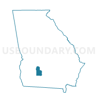
3219 - WARWICK Voting District, Worth County, Georgia
About
Outline

Summary
| Unique Area Identifier | 563181 |
| Name | 3219 - WARWICK Voting District |
| County | Worth County |
| State | Georgia |
| Area (square miles) | 54.38 |
| Land Area (square miles) | 53.82 |
| Water Area (square miles) | 0.56 |
| % of Land Area | 98.97 |
| % of Water Area | 1.03 |
| Latitude of the Internal Point | 31.79213330 |
| Longtitude of the Internal Point | -83.88582330 |
Maps


Graphs
Select a template below for downloading or customizing gragh for 3219 - WARWICK Voting District, Worth County, Georgia


Neighbors
Neighoring Voting District (by Name) Neighboring Voting District on the Map
- 081ARABI - ARABI Voting District, Crisp County, GA
- 081JAMES - JAMESTOWN Voting District, Crisp County, GA
- 1771 - #1 Voting District, Lee County, GA
- 2871 - ASHBURN Voting District, Turner County, GA
- 3217 - DOLES Voting District, Worth County, GA
- 3218 - OAKFIELD Voting District, Worth County, GA
Top 10 Neighboring County Subdivision (by Population) Neighboring County Subdivision on the Map
- Cordele CCD, Crisp County, GA (21,800)
- Ashburn-Sycamore CCD, Turner County, GA (8,227)
- Philema CCD, Lee County, GA (6,693)
- Warwick CCD, Worth County, GA (2,779)
- Arabi CCD, Crisp County, GA (1,639)
Top 10 Neighboring Place (by Population) Neighboring Place on the Map
Top 10 Neighboring Unified School District (by Population) Neighboring Unified School District on the Map
- Lee County School District, GA (28,298)
- Crisp County School District, GA (23,439)
- Worth County School District, GA (21,679)
- Turner County School District, GA (8,930)
Top 10 Neighboring State Legislative District Lower Chamber (by Population) Neighboring State Legislative District Lower Chamber on the Map
- State House District 147, GA (54,428)
- State House District 153, GA (46,273)
- State House District 148, GA (41,718)
Top 10 Neighboring State Legislative District Upper Chamber (by Population) Neighboring State Legislative District Upper Chamber on the Map
Top 10 Neighboring 111th Congressional District (by Population) Neighboring 111th Congressional District on the Map
Top 10 Neighboring Census Tract (by Population) Neighboring Census Tract on the Map
- Census Tract 201, Lee County, GA (6,693)
- Census Tract 102.01, Crisp County, GA (5,483)
- Census Tract 9702, Turner County, GA (5,432)
- Census Tract 9501, Worth County, GA (2,779)
- Census Tract 105, Crisp County, GA (1,639)
Top 10 Neighboring 5-Digit ZIP Code Tabulation Area (by Population) Neighboring 5-Digit ZIP Code Tabulation Area on the Map
- 31763, GA (23,304)
- 31015, GA (21,938)
- 31714, GA (6,474)
- 31712, GA (1,263)
- 31796, GA (1,112)
- 31743, GA (630)
- 31772, GA (482)